Rainy Season Predicted to Start in October: BMKG


BMKGs weather forecast in early 2018.
Indonesia will see the beginning of this years rainy season in October, November, or December, according to Head of the Meteorology, Climatology and Geophysics Agency (BMKG) Dwikorita Karnawati in a press release on Tuesday (4/9).
The rainy season is forecast to begin differently in several regions in the country, while the peak of the rainy season is forecast to begin in January-February next year, she said.
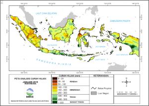
According to Dwikorita, in 78 climate zones in Sumatra, much of Java, East Nusa Tenggara (NTT) province and part of Sulawesi, the rainy season will begin in October, while in 147 climate zones in Sumatra, Java, Bali, West Nusa Tenggara (NTB), East Nusa Tenggara, Sulawesi, Kalimantan, and Papua, the rainy season will begin in December.
The BMKG also predicts that rainy season in Indonesia will be delayed in 273 climate zones and start earlier in 273 climate zones. In 78 climate zones, the beginning of rain season will be the same as the seasonal cycle. In the meantime, rainfall will be normal in 246 climate zones, below the average in 69 climate zones and above the average in 27 climate zones.
Dwikorita added that based on BMKG’s observation, colder air masses and other atmospheric wave phenomena (Rossby and Kelvin Wave) will occur this week and significantly increase rainfall in several regions in Indonesia. She added that there is also the weakening of high pressure centers in Australia, which lowers the intensity of dry and cold air masses from Australia so that the air mass in Indonesia becomes more humid, especially that of in the southern equator.
“This condition causes an increase in rain clouds. Heavy rains occurred in Riau, Bengkulu, Riau Islands, Greater Jakarta, Central Kalimantan, West Kalimantan, South Kalimantan, North Kalimantan, Maluku and Papua last week, ” Dwikorita added.
Therefore, she urged the public to be aware of heavy rain, lightning and strong winds in the next three days in the provinces of Aceh, West Sumatra, Bengkulu, North Kalimantan, Central Sulawesi, Southeast Sulawesi, Maluku, West Papua and Papua.
The BMKG also predicts high waves from 2.5 to 4.0 meters in the next seven days that are expected to occur in Bengkulu, West Lampung, South Banten, West Indian Ocean in Bengkulu, Lampung, and South Indian Ocean in Banten.
In September, 1.25-2.5 meter wave will occur in Central Java Sea, Arafuru Sea, and Sermata- Tanimbar islands, while in West Indian Ocean of Sumatra, South Indian Ocean of Java and East Nusa Tenggara the wave will reach 2.5-4.0 meters.
In October, 1.25-2.5 meter wave will occur in North Natuna Sea, Bengkulu coastal area, Central Java Sea, Arafuru Sea, and Sermata- Tanimbar islands, while in West Indian Ocean of Sumatra, Southern Sea of Java-Sumba, South Indian Ocean of Java and East Nusa Tenggara the wave will reach 2.5-4.0 meters.
In November, 1.25-2.5 meter wave will occur in West Indian Ocean of Sumatra, Sea of Java-Sumba, Sermata-Tanimbar islands and 2.5-4.0 meter waves will occur in South Indian Ocean of Java-Bali. Meanwhile, in December 1.25-2.5 meter wave will occur in Sea of West Sumatra, Southern Sea of Java-NTT, Arafuru Sea, Northern Sea of Papua and 2.5-4.0 meter wave will occur in North Natuna Sea.
Dwikorita also warns of disaster-prone areas that are vulnerable to disasters caused by high rainfall such as floods, puddles, landslides, strong winds, and tornadoes.
In mid-February 2018 the BMKG predicted that the beginning of the dry season in Indonesia will occur from April to May 2018. “Our monitoring of the development of the dry season until the end of August 2018 shows that 99.12% of all regions in Indonesia have entered the dry season, while the remaining 0.88% has not entered the dry season including Payakumbuh (West Sumatra), northern Buru Island (Maluku), and southern Seram Island (Maluku), ” Dwikorita said.
Dwikorita further said that the El-Nino phenomenon will be weak but still active from September until 2019. The weak El Nino, she said, is characterized by warmer sea surface temperatures in the central Pacific region. The phenomena will directly delay the transition of the east wind circulation to the west and finally delay the beginning of the rainy season in much of Indonesia, she added
In early 2019 the west monsoon will be more active in dominating seasonal variations in Indonesia compared to El Nino influence because it is predicted to be neutral early next year.
(Biro Hukum dan Organisasi BMKG/EN) (RI/EP/Naster)