Bali Airport Closed Temporarily Due to Volcanic Ash


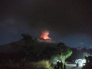
Mount Agung is emitting volcanic ash until Friday (29/6). (Photo: National Disaster Management Agency)
Mount Agung in Bali which continuously sent smoke and volcanic ash since Thursday (28/6) at 10.30 am to Friday (29/6) morning has caused ash rains heading west and southwest.
Data from Himawari satellite from Meteorological, Climatological, and Geophysical Agency (BMKG) shows volcanic ash has covered air space of I Gusti Ngurah Rai International Airport, said Sutopo Purwo Nugroho, Head of Information and Public Relations Center, National Disaster Management Agency (BNPB) in a press release, Friday (29 / 6).
Based on the Coordination Meeting of Mount Agung Impact Management on flight operation at Bali Airport, according to Sutopo, it was decided to close the airport starting on Friday (29/6) at 3 am until 7 pm.
An evaluation will be held again on Friday (29/6) at 12 am, he said.
According to Sutopo, the airport is closed due to safety reason and several operators have made their own decision to cancel their flights since Thursday (28/6).
There are 48 flights cancellation with a total of 8,334 passengers consist of 38 international flights with 6,611 passengers and 10 domestic flights with 1,723 passengers, Sutopo said, adding that the cancelled airlines were Air Asia, Jet Star, Qantas and Virgin.
Meanwhile, according to Sutopo, the results of visual monitoring at Mount Agung Center for Volcanology and Disaster Hazard Mitigation (PVMBG), Ministry of Energy and Mineral Resources (ESDM) in Rendang, until Friday (29/6) at 6 am, show that Mount Agung still sends ash up to 2,500 meters high and shows reddish-look fire crater with stable intensity.
The volcanos status has not been raised and remained at Alert Level (Level 3). The effusive duration still cannot be estimated. Currently, micro tremor is still detected on the seismograph tool which indicates the movement of magma to the surface, added Sutopo.
Seismically, continued Sutopo, rapid increase of seismic amplitude is detected within the last 12 hours. He also added that seismicity is dominated by earthquakes with low frequency and manifested by gas and volcanic ash on the surface.
Ash rains down in some areas at the west and southwest of Mount Agung, such as Purage, Pempatan Rendang, Keladian, Besakih, Br. Beluhu, and Suter Village, Sutopo explained.
Deformation, according to Sutopo, has observed since May 13, 2018 until today with around 5 millimeters (mm) uplift. This indicates the development of pressure by magma inside Mount Agung is still occurring and the inflation has not yet declined.
Dangerous radius is within 4 kilometers from the top of the crater. People living on the slopes of Mount Agung has conducted an independent evacuation, he said, added that a total of 309 people in 3 evacuation points in Tegeh Hamlet of Amerta Bhuana Village, Galih Hamlet of Jungutan Village, and Untalan Hamlet of Jungutan Village in Karangasem Regency were evacuated from their homes.
People are encouraged to remain calm. BNPB continues to coordinate with the Ministry of Transportation, PVMBG, BMKG, Bali Regional Government, and others, Sutopo concluded. (Information and Public Relations Center of BNPB / EN) (STU/MMB/Naster)