BMKG to Conduct Disaster Mapping in Palu, Donggala


 The Meteorology, Climatology and Geophysics Agency (BMKG) conducted a mapping of tsunami affected areas in Palu and Donggala, Central Sulawesi Province. The mapping will later divide Palu and Donggala into a number of zones including safe and unsafe zones.
This mapping is very useful for the regional government as a basis for spatial development plans in coastal areas, including evacuation plans in the event of tsunami in the region, said Deputy for Geophysics of BMKG, Muhammad Sadly in Jakarta, Monday (1/10).
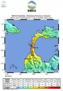
Sadly said, the BMKG has deployed their team shortly after the earthquake to conduct a post-quake survey and dissemination in the affected areas. The survey consisted of macroseismic surveys, microseismic surveys, microzonation surveys, and post-tsunami surveys.
Right after the earthquake occurred (28/9), the BMKG immediately dispatched a survey team to Palu and Donggala. But difficult terrain and lack of electricity supply are our main obstacles when doing the job, he added.
Sadly explained, the macro seismic survey is a monitoring of damage in an area after earthquake. This survey is needed to validate the level of earthquake shocks in the affected area;whereas the microseismic survey is a follow-up quake monitoring after the main earthquake to monitor the development of aftershocks. The monitoring is performed by installing portable earthquake sensors in several locations.
The results of the monitoring are used as considerations by the regional government to make further decisions as well as to tackle hoaxes about the disaster, he said.
Meanwhile, the microzonation survey, continued Sadly, is a review of earthquake-prone areas. The results of microzonation mapping are useful as guidelines for land use in order to find a safe zone for reconstruction process.
In addition, the post-tsunami survey is a review of traces of tsunami waves starting from the coast to the mainland. This survey, Sadly added, is significantly needed to validate the results of tsunami modeling that the BMKG has conducted when issuing tsunami early warnings.
Until now, there is no certain way or technology that can predict when an earthquake will occur or how strong it will be, he said.
On the same occasion, Sadly asked people in Palu and surrounding areas not to believe the news about the disaster that was spreading through social media. Because in a time like this, hoaxes are deliberately spreaded by irresponsible people to trigger panic, he added.
Sadly said, the BMKG is the only institution responsible for updating weather, maritime, aviation, climate, air quality, earthquakes and tsunami forecasts. Therefore, he asked the public to remain calm and do not trust many false news spreading through social media.
Follow the instructions of the officers in the field. Do not be affected by unverified news and only trust official information from the BMKG, he concluded. (BMKG / EN Public Relations) (STU/MMB/Naster)