BMKG Warns Against Hydro Meteorological Disasters


Information from the BMKG on Disaster Preparedness. Photo by: the BMKG.
Increased rainfall in the rainy season may cause hydro meteorological disasters in most parts of Indonesia, according to the Meteorology, Climatology and Geophysics Agency (BMKG) in its press release, Thursday (13/12).
“There are 72 floods, 74 landslides, and 77 tornadoes occur in several regions last November,” the release states.
Deputy of Climatology of the BMKG Herizal stated that the highest rainfall recorded in last November was 400 mm, which dropped in a single day in Karang Nunggal, Tasikmalaya, while the highest accumulation of rainfall (1,325 mm) occurred in the same location.
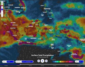
Based on updated data of the BMKG on 13 December 2018, 62% of Indonesia’s territory was declared to have entered the rainy season.
“Several regions have seen high rainfall (> 150 mm/dasarian), including West Sumatra, Central Riau, West Jambi, Muko-muko, Pekanbaru, Kampar, Kerinci, Belitung, Cilacap, Semarang, Kapuas Hulu, Samarinda, Flores , Sorong, Nabire, and Mimika,” Herizal said.
He added that low category rainfall (0-50 mm/dasarian) occur in central North Sumatra, north coast of West Java, Special Capital Region of Jakarta, Situbondo, Banyuwangi, most of Central Sulawesi, Bombana, Kolaka, Ambon, Kairatu, and Merauke.
Herizal went on to say that for the next 10 days, very high rainfall accumulation (> 150 mm/dasarian) will occur in the western part of Sumatra/West Coast of Sumatera (Aceh, North Sumatra, West Sumatra, western part of Jambi, western part of South Sumatra and Bengkulu), North Bangka, Belitung, western part of West Kalimantan, southern part of South Sulawesi, and parts of Papua (around the Jayawijaya Mountains).
Herizal also warned the public to be aware of areas forecast to have high rainfall, especially in flood-prone areas such as most of Sumatra, Banten, parts of West Java, parts of Central Java, parts of Kalimantan, West Sulawesi, Central Sulawesi, and a small part of Papua. He also said that a more detailed, 10-day flood potential map has been prepared by the BMKG, the Geospatial Information Agency (BIG) and Directorate General of Water Resources of the Ministry of Public Works and Public Housing (DJSDA-PU).
In the meantime, anti-trade winds monsoon circulation will occur in Indonesia until the end of December 2018, while other areas were dominated by trade winds (southern part of Sumatra, Java, Bali and Nusa Tenggara) and south winds (southern regions of the equator), Herizal said
Cyclonic pattern in West Sumatra waters, West Kalimantan waters and ??air mass in South Kalimantan waters, Southeast Sulawesi, Maluku, and North Papua may form rain clouds, he added.
In general, the western part of Indonesia will receive additional water supply due to the active MJO (Madden-Julian Oscillation)/wet air mass so that rain clouds are easier to occur, Herizal stated.
Regarding the global El Nino phenomenon, Herizal said that the World Meteorological Organization (WMO) has stated that El Nino conditions had been fulfilled in terms of the warmth of the Pacific Ocean, but the interaction between the oceans and the atmosphere has not occurred. “The atmospheric movement has not shown a situation that normally occurs in El Nino conditions,” he said.
According to Herizal, the BMKG finds the warming of sea surface temperatures in the central and eastern Pacific indicates a weak El Nino (> 0.5 – 1.0 ?), while in the end of November 2018 the Indian Ocean showed a positive dipole mode conditions that did not contribute to the addition of water vapor in the western part of Indonesia.
“The temperature of Indonesian waters is in normal condition, with cooling or heating of the sea surface temperature occur between 0.5 to 1° C from the normal average,” he said, adding that the cooling sea surface temperature occur in the South of Bali to West Nusa Tenggara, and in the Straits of Makassar while warmer sea surface temperatures occur in northern Sumatra, the Timor Sea, the Seram Sea and the Maluku Sea.
For the record, the BMKG provides a 24-hour weather information service through the call center 021-6546315/18, website http://www.bmkg.go.id, social media (twitter, Instagram, and Facebook @infobmkg) and android application infobmkg, Herizal concluded. (Humas BMKG/EN)
Translated by: Ridwan Ibadurrohman
Edited by: Ersan Pamungkas