Higher Rainfall Predicted at End-October


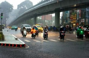 The Meteorology, Climatology, and Geophysics Agency (BMKG) urged the public to be aware of the increase in rainfall in some regions of Indonesia.
We predict the increase to occur in most regions of Western Indonesia, Deputy for Meteorology at the BMKG Drs. Mulyono R. Prabowo, M.Sc, said in his statement in Jakarta, Saturday (27/10).
The increase, according to Prabowo, was caused by several factors, including the presence of cyclonic circulation around the Sumatra region which caused a concentration of air mass in the region.
The air mass concentration causes air conditions to be more humid that support the making of rain clouds, Prabowo said, adding that this situation will last for the next 3 days.
Prabowo said that the circulation activity will decrease and be replaced by the wind convergence area that extends from Sumatra to northern Kalimantan. The convergence will also support rain cloud forming.
On the contrary, Prabowo continued, the rain potential is predicted to remain minimal in eastern areas of Java Island to East Nusa Tenggara, Sulawesi, Maluku, and Papua. The lack of rainfall is caused by the dominance of the dry air mass observed in the region and the wind patterns that tend to be scattered which inhibit the forming of rain clouds.
Areas with high rainfall potential on 26 to 28 October 2018, according to Prabowo, are, among others, Aceh, North Sumatra, West Sumatra, Bengkulu, Riau, South Sumatra, Bangka Belitung, Banten, Jakarta, West Java, Central Java, Central Kalimantan, West Kalimantan, North Kalimantan, and Central Sulawesi.
Furthermore, the regions with heavy rain potential on 29 to 31 October 2018 are, among others, Aceh, North Sumatra, West Sumatra, Bengkulu, South Sumatra, Bangka Belitung. Jambi, Riau, Riau Islands, Banten, Jakarta, West Java, Central Java, East Java, Central Kalimantan, West Kalimantan, North Kalimantan, Central Sulawesi, West Sulawesi, Gorontalo, and Papua.
The potential for 2.5 to 4.0 meters high waves is predicted to occur in Enggano West Waters, South Banten Waters, Southern Sunda Strait, South Java to Sumbawa Waters, West Indian Ocean Enggano to Banten, southern Indian Ocean Java to West Nusa Tenggara, North Talaud Islands Waters, North Halmahera Waters, Halmahera Sea, north of West Papua Waters.
Prabowo also called the public to remain vigilant and careful of the impacts such as floods, landslides, flash floods, inundation, strong winds, fallen trees, and slippery roads.
For those who want to get the latest information from the BMKG, the BMKG opens a 24-hour weather information service through call center 021-6546315/18; http://bmkg.go.id; follow @infobmkg on Twitter; or directly contact the nearest BMKG office. (Humas BMKG/ES)
Translated by: Galuh Wicaksono
Edited by: Yuyu Mulyani