Indonesia Launches New State Map


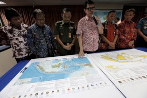 The Indonesian Government, through Coordinating Ministry for Maritime Affairs, on Friday (14/7), launched an updated version of the map of the Unitary State of the Republic of Indonesia (NKRI).
Before the launching, the map was signed by the officials from 21 related ministries and institutions, including Coordinating Ministry for Political, Legal, and Security Affairs, Coordinating Ministry for the Economy, Coordinating Ministry for Maritime Affairs, Ministry of Home Affairs, Ministry of Foreign Affairs, Ministry of Defense, Ministry of Law and Human Rights, Ministry of Finance, Ministry of Energy and Mineral Resources, Ministry of Transportation, Ministry of Environment and Forestry, Ministry of Maritime and Fisheries, Indonesian National Defense Forces, Indonesian National Navy, Center for Hydrology and Oceanography of the Indonesian National Navy, Indonesian National Police, Maritime Security Board (Bakamla), Indonesian Geospatial Information Agency (BIG), Indonesian Institute of Sciences (LIPI), Agency for the Assessment and Application of Technology (BPPT), as well as Meteorology, Climatology, and Geophysics Agency (BMKG).
In the meantime, Deputy to the Coordinating Minister for Maritime Affairs for Maritime Sovereignty Affairs Arif Havas Oegroseno who led the event said that there are several backgrounds that led to the decision to update the map. A treaty between Indonesia and Singapore on the maritime boundaries in the western and eastern stretch of both countries has entered into force, not to mention, an agreement on Exclusive Economic Zone (EEZ) between Indonesia and the Philippines which has been agreed on and ratified shall came into force in the near future, Oegroseno said.
The second reason, he added, is related to the Philippines and China arbitration decision which influenced the jurisprudence of international law that states small islands or reef that cannot sustain human lives are not entitled to 200-nautical mile EEZ. Therefore, a number of small islands of our neighboring countries are only entitled to 12- nautical mile EEZ, he added. We have also updated the sea column on the northern side of Natuna, Oegroseno added.
Since 1970s, the naming of continental shelf in that area was based on the wind direction, namely North Natuna Block, South Natuna Block, Southeast Natuna Block. “In order to create clarity or similarity between the water column and the continental shelf, the national team has agreed that the water column should be called North Natuna Sea,” Oegroseno noted.
The naming of North Natuna Sea was adjusted to be in line with a number of oil and gas exploration blocks conducted in that continental shelf, Oegroseno added.
Another reason is that the Government wants to affirm the claim in the Malacca Strait by simplifying borderline claims to facilitate law enforcement, he said. Moreover, there was already a clear borderline in the areas near the border of Singapore. Considering that position, we need to update the map so that our security and law enforcement officers of the Indonesian National Navy, custom and excise office, and Indonesian Sea and Coast Guard (KPLP) can conduct patrol at ease in those areas, Oegroseno said.
In completing the map, Oegroseno admitted that related ministries and institutions had six sessions of internal meeting since 2016. He also said that the unfinished maritime boundary with the neighboring countries would be completed by the Government immediately. We are ready to complete it during a negotiation that will be made in accordance with the United Nations Convention on the Law of the Sea, UNCLOS 1982, Oegroseno firmly said.
Thus, the Government of Indonesia will continue conducting routine patrol to affirm the State Practice in the areas claimed by Indonesia. In accordance with the State Practice, we will continue patroling in the areas claimed by Indonesia as we always do. Regarding the State Practice and its implementation, we will not give up our claim, Oegroseno concluded. (Biro Informasi dan Hukum Kemenko Kemaritiman/ES) (RA/EP/YM/Naster)