BMKG Warns of High Waves Until This Friday
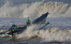
 The Meteorology, Climatology and Geophysics Agency (BMKG) has stated there will be the potential for high waves from Tuesday (11/6) to Friday (14/6) in some Indonesian waters.
The high waves are caused by wind in the north of the Halmahera Sea, the BMKG stated at their press release, Tuesday (11/6).
For the record, the wind in the north of the equator usually blows from the east to the southeast at a speed of 4-15 knots, whereas the wind in the southern part usually blows from the east to the southeast at a speed of 4-25 knots.
Furthermore, the highest wind speed occurrs in Enggano waters to southern Java, waters of Sawu Island to Rote Island, Timor Sea, Southeast Sulawesi waters, Banda Sea, water of Sermata Islands to Tanimbar Islands, southern waters of Kei Islands to Aru Islands, Arafuru Sea, waters of Yos Sudarso Island to Merauke. This condition causes an increase in wave height at surrounding areas, the release says.
The potential of increase in wave height by 1.25-2.50 meters is also expected to occur in: eastern waters of Simeulue and Mentawai Islands, southern Sape Strait to Sumba Strait, Sawu Sea to Ombai Strait, southern Flores waters, waters of Kupang to Rote, South Timor Sea, Karimata Strait, Java Sea, southern Kalimantan waters, Kotabaru waters, southern Makassar Strait, eastern of Selayar Islands waters, Flores Sea, southern Bone Bay, Bau Bau to Wakatobi waters, Manui to Kendari waters, southern of Buru Island to Seram Island waters, Sermata Islands to Tanimbar Islands waters, Kei Islands to Aru Islands waters, Banda Sea, Amamapare waters, and western of Yos Sudarso Island waters.
Meanwhile, the regions that are expected to experience an increase in wave height by 2.50 to 4 meters are Enggano to Bengkulu waters, western Lampung waters, southern Sunda Strait to Sumbawa Island waters, Bali Strait, Lombok Strait, Alas Strait, southern of Sumba Island to Sawu Island and Rotte Island waters, southern of Timor Sea, eastern of Wakatobi Islands waters, and southern Sermata Islands to Tanimbar Islands waters.
The release also stated that the regions to expect 4 to 6 meters of wave height are western of Mentawai to Bengkulu waters, western Lampung waters, Mentawais western Indian Ocean to Lampung, southern of Sunda Strait, southern of Java waters to Lombok waters, southern of Bali Strait-Lombok Strait-Alas Strait, southern of Javas Indian Ocean to Lombok.
The BMKG also specifically warned fishermen to be aware of their safety when they sail. Fishing boats must be aware of wind speed of more than 15 knots and wave height above 1.25 meters; barges vessels must be aware of wind speed of more than 16 knots and wave height above 1.5 meters; ferry vessels must be aware of wind speed of more than 21 knots and wave height above 2.5 meters; and large-sized vessels such as cargo/cruise vessels must be aware of wind speed of more than 27 knots and wave height above 4.0 meters. (Humas BMKG/ES)
Translated by: Galuh Wicaksono
Edited by: Mia Medyana


